---
title: "The world, sister by sister"
subtitle: "TidyTuesday 2026-05-12 · Twinned (sister) cities worldwide"
date: 2026-06-09
---
::: {.callout-tip icon=false}
## Session 1 · co-developed
This page came out of a live, turn-by-turn conversation between Jon Minton and Claude
(Fable 5) — questions, plots and interpretation built together in real time. The
[Session 2 pages](index.qmd) were instead produced by Claude working autonomously.
:::
5,470 cities, 10,596 twinning links — a global network of "sister city" agreements
stretching back to post-war reconciliation efforts. This page is built around a
single interactive map: **hover a city to fan out its twin links; click to pin
them** so you can compare several cities at once.
```{r setup}
#| include: false
library(tidyverse)
library(jsonlite)
cities <- read_csv("data/twin_cities.csv", show_col_types = FALSE)
links <- read_csv("data/twin_links.csv", show_col_types = FALSE)
deg <- bind_rows(tibble(id = links$source), tibble(id = links$target)) |>
count(id, name = "deg")
cont_pal <- c(Africa = "#e6952f", Asia = "#d4546b", Europe = "#3f7cac",
"North America" = "#5aa469", "South America" = "#9b59b6",
Oceania = "#16a3a3")
cdat <- cities |>
left_join(deg, by = "id") |>
filter(!is.na(lat), !is.na(lng)) |>
transmute(
id, name, country,
continent = coalesce(continent, "Other"),
lat = round(lat, 3), lng = round(lng, 3),
deg = coalesce(deg, 0L),
col = coalesce(cont_pal[continent], "#888888")
)
# adjacency keyed by id -> vector of neighbour ids (both directions)
adj <- bind_rows(
links |> transmute(a = source, b = target),
links |> transmute(a = target, b = source)
) |>
filter(a %in% cdat$id, b %in% cdat$id) |>
distinct() |>
summarise(nb = list(b), .by = a)
adj_list <- set_names(adj$nb, adj$a)
data_json <- toJSON(list(
cities = cdat,
adj = adj_list
), auto_unbox = TRUE, dataframe = "rows")
```
```{r emit-data}
#| echo: false
#| results: asis
cat('<script>\nconst TWIN = ', data_json, ';\n</script>\n', sep = "")
```
```{=html}
<link rel="stylesheet" href="https://unpkg.com/leaflet@1.9.4/dist/leaflet.css"/>
<script src="https://unpkg.com/leaflet@1.9.4/dist/leaflet.js"></script>
<style>
#twinmap { height: 620px; border-radius: 8px; border: 1px solid #ddd; }
#twin-info {
font: 14px/1.4 system-ui, sans-serif; margin: 8px 2px; min-height: 2.6em;
color: #333;
}
#twin-info b { color: #111; }
.twin-pill {
display:inline-block; background:#2c3e50; color:#fff; border-radius:10px;
padding:1px 8px; font-size:12px; margin-left:6px;
}
.leaflet-tooltip.twin-tip { font-weight:600; }
</style>
<div id="twin-info">Hover any city to see its twin links · click to pin them · click again to release.</div>
<div id="twinmap"></div>
<script>
(function () {
const byId = {};
TWIN.cities.forEach(c => byId[c.id] = c);
const adj = TWIN.adj;
const map = L.map('twinmap', { worldCopyJump: true }).setView([25, 10], 2);
L.tileLayer('https://{s}.basemaps.cartocdn.com/light_all/{z}/{x}/{y}{r}.png', {
attribution: '© OpenStreetMap, © CARTO', subdomains: 'abcd', maxZoom: 12
}).addTo(map);
const linkLayer = L.layerGroup().addTo(map); // transient (hover) lines
const pinLayer = L.layerGroup().addTo(map); // pinned lines
const markers = {};
let pinned = new Set();
function radius(deg) { return Math.max(2.2, Math.min(13, 1.6 + Math.sqrt(deg) * 1.3)); }
// draw markers
TWIN.cities.forEach(c => {
const m = L.circleMarker([c.lat, c.lng], {
radius: radius(c.deg), color: '#fff', weight: 0.5,
fillColor: c.col, fillOpacity: 0.82
});
m.cityId = c.id;
m.bindTooltip(`${c.name}, ${c.country} — ${c.deg} link${c.deg===1?'':'s'}`,
{ className: 'twin-tip', direction: 'top' });
m.on('mouseover', () => showLinks(c.id, linkLayer, false));
m.on('mouseout', () => { if (!pinned.size) linkLayer.clearLayers(); else redrawPins(); });
m.on('click', () => togglePin(c.id));
m.addTo(map);
markers[c.id] = m;
});
function lineFor(a, b, opts) {
let lng2 = b.lng;
if (Math.abs(b.lng - a.lng) > 180) lng2 += (b.lng > a.lng ? -360 : 360); // shortest path
return L.polyline([[a.lat, a.lng], [b.lat, lng2]], opts);
}
function showLinks(id, layer, persistent) {
layer.clearLayers();
const a = byId[id];
let nbs = adj[id] || [];
if (!Array.isArray(nbs)) nbs = [nbs]; // jsonlite unboxes single-element arrays
nbs.forEach(nid => {
const b = byId[nid]; if (!b) return;
lineFor(a, b, {
color: a.col, weight: persistent ? 1.6 : 1.1,
opacity: persistent ? 0.85 : 0.6
}).addTo(layer);
});
L.circleMarker([a.lat, a.lng], {
radius: radius(a.deg) + 3, color: '#111', weight: 2, fill: false
}).addTo(layer);
const info = document.getElementById('twin-info');
if (!persistent) {
info.innerHTML = `<b>${a.name}</b>, ${a.country}` +
`<span class="twin-pill">${nbs.length} twin link${nbs.length===1?'':'s'}</span>` +
(pinned.size ? ` · ${pinned.size} pinned` : '');
}
}
function redrawPins() {
linkLayer.clearLayers();
pinLayer.clearLayers();
pinned.forEach(id => showLinks(id, pinLayer, true));
}
function togglePin(id) {
if (pinned.has(id)) pinned.delete(id); else pinned.add(id);
redrawPins();
const info = document.getElementById('twin-info');
info.innerHTML = pinned.size
? `<b>${pinned.size}</b> cit${pinned.size===1?'y':'ies'} pinned` +
`<span class="twin-pill">click a pinned city to release</span>`
: 'Hover any city to see its twin links · click to pin them.';
}
})();
</script>
```
::: {.callout-tip}
## Try this
Pin **Saint Petersburg** and **Rio de Janeiro** — the two most-twinned cities in
the data (96 and 94 links) — and watch their fans of lines reach across nearly
every continent. Then pin a mid-sized European capital next to them: the
contrast in reach is the whole story of sister-city diplomacy.
:::
```{r setup-static}
#| include: false
theme_set(theme_minimal(base_size = 13))
```
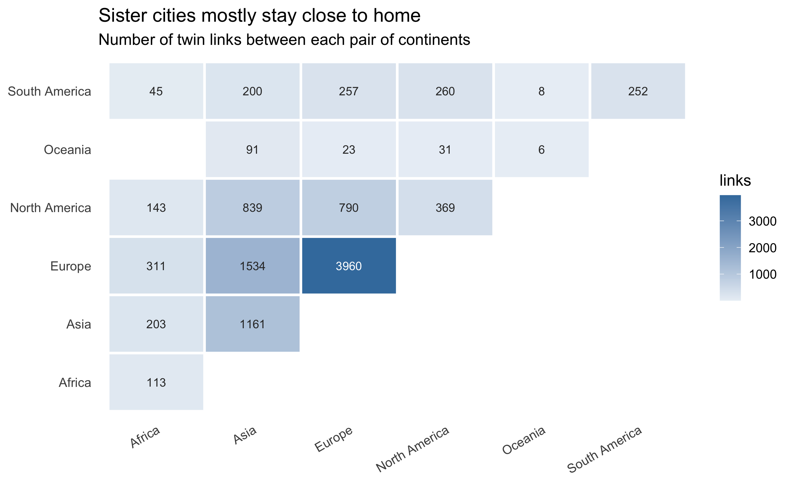
## Who twins with whom?
The interactive map shows individual cities; zoom out and the network has a
strong *regional* grain. Counting links by the continents they connect:
```{r flow-matrix}
#| fig-height: 5.5
#| fig-cap: "Twin links by the pair of continents they connect. The diagonal (within-continent) dominates — sister cities are mostly neighbours."
cont <- cities |> select(id, continent)

pairs <- links |>
  left_join(cont, by = c("source" = "id")) |>
  rename(c1 = continent) |>
  left_join(cont, by = c("target" = "id")) |>
  rename(c2 = continent) |>
  filter(!is.na(c1), !is.na(c2)) |>
  mutate(
    a = pmin(c1, c2), b = pmax(c1, c2)
  ) |>
  count(a, b)

ggplot(pairs, aes(a, b, fill = n)) +
  geom_tile(colour = "white", linewidth = 1) +
  geom_text(aes(label = n), size = 3.4,
            colour = ifelse(pairs$n > max(pairs$n) / 2, "white", "grey20")) +
  scale_fill_gradient(low = "#eaf0f6", high = "#3f7cac", name = "links") +
  labs(
    title = "Sister cities mostly stay close to home",
    subtitle = "Number of twin links between each pair of continents",
    x = NULL, y = NULL
  ) +
  theme(axis.text.x = element_text(angle = 30, hjust = 1),
        panel.grid = element_blank())
```
The within-continent diagonal dominates — Europe–Europe especially, the legacy
of post-war Franco-German *jumelage* and the EU's deliberate cultivation of
cross-border municipal ties. The brightest off-diagonal cell is usually
Europe paired with Asia, reflecting the dense web of European–Chinese and
European–Japanese partnerships built during the late-20th-century opening.
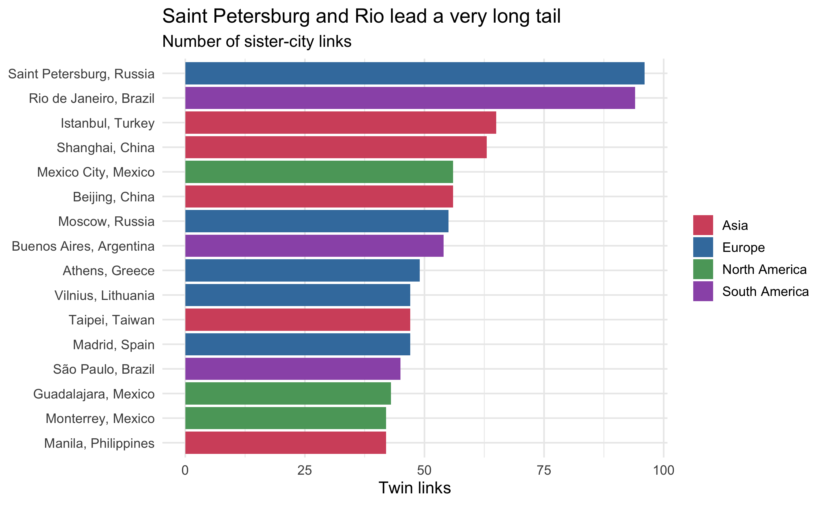
## The most connected cities
```{r top-cities}
#| fig-height: 5.5
#| fig-cap: "The 15 most-twinned cities."
deg |>
  left_join(cities, by = "id") |>
  slice_max(deg, n = 15) |>
  mutate(label = paste0(name, ", ", country),
         label = fct_reorder(label, deg)) |>
  ggplot(aes(deg, label, fill = continent)) +
  geom_col() +
  scale_fill_manual(values = cont_pal, name = NULL) +
  labs(
    title = "Saint Petersburg and Rio lead a very long tail",
    subtitle = "Number of sister-city links",
    x = "Twin links", y = NULL
  )
```
A handful of "diplomatic hub" cities (Saint Petersburg, Rio, Istanbul, Shanghai)
carry dozens of links each, while the median city in the data has just one or
two — the signature of a network where a few well-resourced municipalities run
active international offices and most do not.
## Six degrees of twinning: Edinburgh to Jinan
Because twinning stitches distant cities together, even places with nothing in
common are often only a few hops apart. The shortest chain of sister-city links
from **Edinburgh** to **Jinan, China** — found by breadth-first search over the
whole network — is just **three hops**, and it routes *out* of China through a
European bridge before returning:
```{=html}
<div id="pathmap" style="height:520px;border-radius:8px;border:1px solid #ddd;margin-bottom:6px;"></div>
<div id="path-caption" style="font:14px/1.4 system-ui,sans-serif;color:#444;margin:2px;">
Edinburgh → Xi'an → Maribor → Jinan. Hover a marker for the city; the chain is drawn in order.
</div>
<script>
(function () {
function draw() {
if (typeof L === 'undefined') { setTimeout(draw, 150); return; }
const path = [
{name: "Edinburgh", country: "United Kingdom", lat: 55.9533, lng: -3.1892},
{name: "Xi'an", country: "China", lat: 34.2611, lng: 108.9422},
{name: "Maribor", country: "Slovenia", lat: 46.5500, lng: 15.6333},
{name: "Jinan", country: "China", lat: 36.6667, lng: 116.9833}
];
const map = L.map('pathmap', { worldCopyJump: true }).setView([50, 55], 3);
L.tileLayer('https://{s}.basemaps.cartocdn.com/light_all/{z}/{x}/{y}{r}.png', {
attribution: '© OpenStreetMap, © CARTO', subdomains: 'abcd', maxZoom: 12
}).addTo(map);
const stopcol = ['#1b6ca8', '#d4546b', '#2c7a4d', '#d4546b'];
// draw the ordered chain
for (let i = 0; i < path.length - 1; i++) {
const a = path[i], b = path[i + 1];
let lng2 = b.lng;
if (Math.abs(b.lng - a.lng) > 180) lng2 += (b.lng > a.lng ? -360 : 360);
L.polyline([[a.lat, a.lng], [b.lat, lng2]],
{ color: '#e08214', weight: 3, opacity: 0.85, dashArray: '1,0' })
.addTo(map);
// midpoint hop label
const mid = L.latLng((a.lat + b.lat) / 2, (a.lng + lng2) / 2);
L.marker(mid, { opacity: 0,
icon: L.divIcon({ className: 'hoplbl', html: `<span style="background:#e08214;color:#fff;border-radius:9px;padding:1px 7px;font:600 12px system-ui;">hop ${i + 1}</span>`, iconSize: [54, 18] }) })
.addTo(map);
}
// markers + labels, numbered in path order. Xi'an and Jinan are both in
// eastern China, so fan their labels left/right to avoid overlap.
const dir = ['top', 'left', 'top', 'right'];
path.forEach((c, i) => {
L.circleMarker([c.lat, c.lng], {
radius: 8, color: '#fff', weight: 2, fillColor: stopcol[i], fillOpacity: 0.95
}).addTo(map).bindTooltip(`${i + 1}. ${c.name}, ${c.country}`,
{ permanent: true, direction: dir[i], className: 'twin-tip' });
});
map.fitBounds(path.map(c => [c.lat, c.lng]), { padding: [60, 60] });
}
draw();
})();
</script>
```
The middle hop is the giveaway: there is no direct Xi'an–Jinan twin, because
Chinese cities overwhelmingly twin *outward* with foreign partners rather than
with each other. So the shortest link between two Chinese cities runs through
**Maribor, Slovenia** — a small city that happens to be twinned with both. Three
hops, ~16,000 km of round-trip geography, to connect two cities in the same
country.